Most pilots know the basics of VFR charts such as sectionals or TACs (Terminal Area Charts). “Landmarks, airports, navaids, airspace. Got it.” But there’s a lot more under the hood.
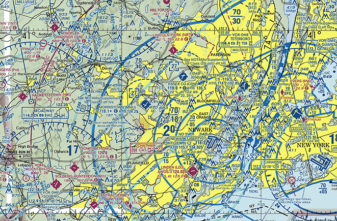
Quick review. Sectionals are 1:500,000 scale charts which cover the conterminous U.S. and Alaska. They’re published every six months; most Alaska charts, annually. There are 54 of them, each named for a prominent city contained within, other than the “Hawaiian Islands” chart.
TACs are 1:250,000 scale. The higher detail is valuable for users operating in, under or near the Class B airspace depicted within. These charts are also published every six months; Puerto Rico and the Virgin Islands, annually.
There are also VFR Flyway Planning Charts. These are printed on the reverse sides of selected Terminal Area Charts and they’re 1:250,000 scale. There are some others, too; they’re “specialty products” such as the U.S. Gulf Coast VFR Aeronautical Chart, Helicopter Route Charts for various parts of the country, and a few more.
Is that chart current?
Here’s a question worth pondering. If most VFR sectionals and TACs are only updated every six months, how are pilots made aware of changes which take place during that time? Airport closures, airspace revisions, frequency changes and new obstructions are just a few examples of what might occur during a charting cycle.
The answer is twofold. 1) Critical information may always be transmitted via NOTAM. 2) Aeronautical Chart Bulletins. The FAA conveniently publishes these as separate documents on their website, but they “live” within the Chart Supplement.
The Chart Supplement is so named because it is in fact designed to be used in conjunction with, and as a supplement to, FAA charting products. Formerly called the “A/FD,” or Airport/Facilities Directory, it now contains the A/FD among other important information. The title change reflects the significance of this other data. Within the Chart Supplement, published every 56 days, pilots can find the following major sections, conveniently listed within the Table of Contents:
- GENERAL INFORMATION
- SECTION 1: AIRPORT/FACILITY DIRECTORY LEGEND
- SECTION 2: AIRPORT/FACILITY DIRECTORY
- SECTION 3: NOTICES
- SECTION 4: ASSOCIATED DATA
- SECTION 5: AIRPORT DIAGRAMS
Section 3: Notices, is where pilots can find Aeronautical Chart Bulletins, Special Notices, and Regulatory Notices. Aeronautical Chart Bulletins is where the FAA publishes changes to all of its VFR charting products. This section states, “The general policy is to include only those changes to controlled airspace and special use airspace that present a hazardous condition or impose a restriction on the pilot, and major changes to airports and radio navigational facilities, thereby providing the VFR pilot with the essential data necessary to update and maintain chart currency. “
It would be safe to say that these two publications must go hand-in-hand, not only for the ACBs but also the A/FD itself. In fact, a quick glance at any VFR sectional legend reveals numerous references to the Chart Supplement, advising users to consult the document for more information.
Hey, what’s that?
How many times have you noticed a feature on a VFR sectional or TAC and couldn’t identify it? Wouldn’t it be handy to have one single document which serves as a “decoder ring” for all of the FAA’s charting products?
Good news – there is one. It’s called the Aeronautical Chart User’s Guide.
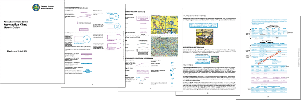
This is a treasure trove of aeronautical chart information. The VFR section alone is 18 pages. The detail far exceeds the condensed legends found on the VFR sectional and TAC. Would you believe there are four pages dedicated solely to hydrography? (… Given that 71% of the Earth is covered by water, perhaps that shouldn’t be a surprise!)
Together, NOTAMS, the Chart Supplement, the Aeronautical Chart User’s Guide and the sectional/TAC itself make up the complete VFR view of the National Airspace System. This is the “Secret Sauce,” if you will, which unlocks the full power of the FAA’s VFR charting products. This makes for a fully informed pilot… and happy flying!
Safe Flights!
-Ryan